Lasers vs. Photos: Which Drone Mapping Magic is Right for Your Lethbridge Project?
So, you know drones can make cool maps, right? It’s super useful for all sorts of businesses here in Lethbridge and Southern Alberta for surveying, planning, and just seeing things better. But there are actually a couple of main ways drones do this map-making magic: LiDAR (think lasers!) and Photogrammetry (think fancy photo-stitching). Which one’s best for you?
Good question! We use both here at Coalbanks Creative, and picking the right one depends on your project. Let’s break down the difference in plain English so you can figure out what makes sense for your needs.
How Drones Make Maps: The Two Main Flavours
Okay, both LiDAR and Photogrammetry end up giving you awesome 3D maps from a drone, but they get there in totally different ways:
-
LiDAR: Pew Pew Pew with Lasers!
Imagine your drone shooting out tons of tiny, invisible laser beams as it flies – like a super-fast, super-accurate measuring tape made of light. That’s LiDAR! It’s an active system, meaning it sends something out:
- Shoots Lasers: Zaps the ground with hundreds of thousands of laser pulses every second.
- Times the Bounce-Back: Measures exactly how long it takes for each laser pulse to hit something and bounce back to the drone.
- Makes a “Point Cloud”: Uses those measurements (plus fancy GPS) to create a super-detailed 3D map made of millions of tiny points, showing the exact shape and height of everything.
- Sees Through Trees (Kind Of!): This is LiDAR’s superpower! Some laser pulses sneak through leaves and branches to hit the actual ground underneath. Great for mapping forests or areas with bushes.
-
Photogrammetry: Building 3D from Photos
Photogrammetry is more like being a super-smart detective with a camera. It’s passive, meaning it just uses the light that’s already there:
- Takes Lots of Overlapping Pics: The drone flies around snapping hundreds (or thousands!) of high-res photos from slightly different angles, making sure they overlap a lot.
- Software Plays Connect-the-Dots: Fancy software looks at all those photos, finds the same points in different pictures, and uses some clever math (triangulation!) to figure out where everything is in 3D space.
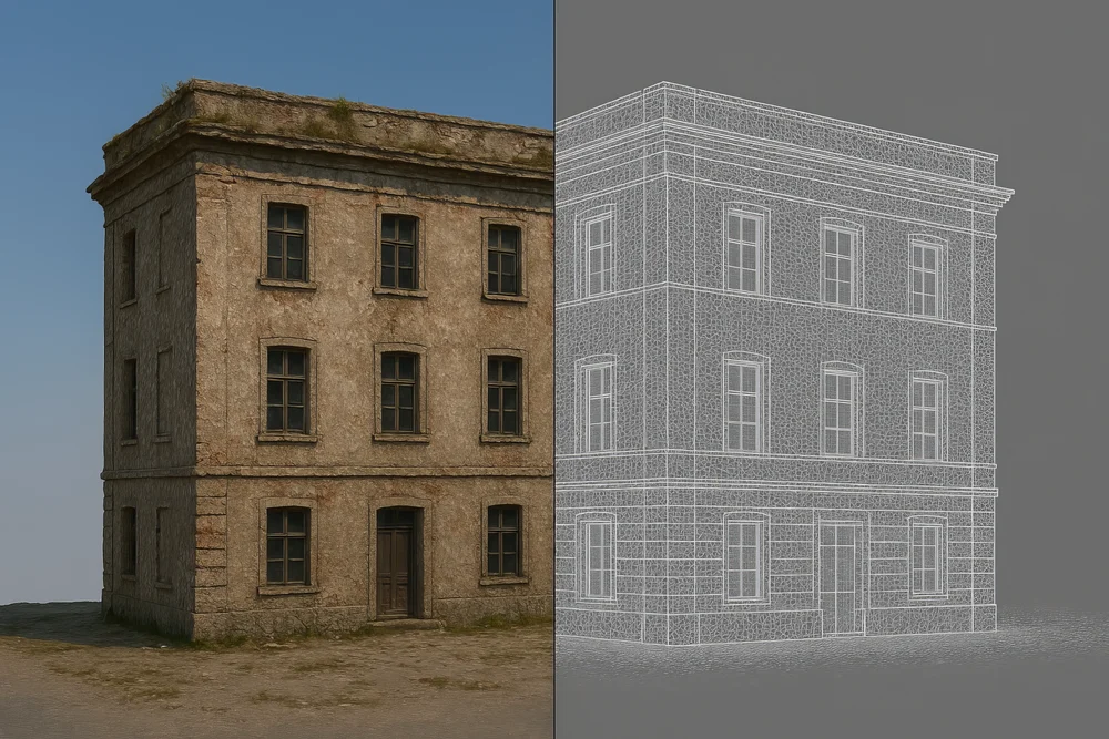
- Makes Pretty Maps & Models: The result? You get things like realistic-looking 3D models and super-detailed aerial maps (orthomosaics) that look like one giant, perfectly flat photo.
- Needs a Clear View: The catch? Photogrammetry needs to see the ground clearly. If there are lots of trees or bushes, it maps the top of the green stuff, not the dirt underneath.
The Gist: LiDAR uses lasers to measure directly. Photogrammetry uses photos and smart software to build a 3D picture.
Okay, So Which is Better? (It Depends!)
Choosing between LiDAR and Photogrammetry really comes down to what you need for your project here in Southern Alberta. Let’s compare:
-
How Accurate Are We Talking? Both can be really accurate (down to centimeters!) if done right, especially with some ground markers (GCPs) or fancy GPS (RTK/PPK).
- LiDAR: Often gets the gold star for vertical accuracy (how high things are). It’s super consistent even on tricky ground.
- Photogrammetry: Also very accurate, especially horizontally. Vertical accuracy is usually great too, but might be a tiny bit less precise if the ground looks too uniform (like a flat field) or the lighting is weird. Honestly, for most jobs, both are accurate enough for serious work!
-
Dealing with Trees & Bushes: This is where they really differ!
- LiDAR: The clear winner here! Its lasers can sneak through gaps in leaves and branches to map the actual ground underneath. Super important if you need to know the terrain shape in a forested area (like down in the coulees or Waterton) or before clearing a bushy site.
- Photogrammetry: Not so great with greenery. It basically maps the tops of the trees and bushes. If you need to see the ground under the plants, photogrammetry isn’t your best bet. It’s perfect for open fields or construction sites after they’ve been cleared.
-
What About the Wallet? (Cost & Ease of Use):
- Photogrammetry: Usually the more budget-friendly option. It uses high-quality cameras that are more common on drones, and the software workflow can be a bit simpler to get started with. Great if you need awesome visuals without breaking the bank.
- LiDAR: Historically, this tech was pricier because the laser sensors are specialized. Processing the data also takes a bit more know-how. But good news! LiDAR drones are getting more affordable. It’s worth the investment if you absolutely need to see through vegetation or need that top-tier vertical accuracy.
Quick Recap: LiDAR = King of seeing through trees and nailing vertical heights. Photogrammetry = Awesome visuals, great accuracy in the open, often easier on the budget.
So, Which One Do You Need? (Lethbridge Examples)
The best choice depends on your job! Here are some common scenarios around here:
-
Go for LiDAR if you’re:
- Working in the Woods (or Coulees!): Mapping forests near Waterton, checking out timber, or understanding water flow where there are lots of trees.
- In Mining or Gravel Pits: Need super-accurate stockpile volumes or need to map the ground before clearing vegetation.
- Doing Fancy Farm Stuff: Analyzing things like orchard layouts or studying soil erosion under plant cover.
- Planning to Build on Bushy Land: Need to know the exact ground shape under all that natural greenery near Lethbridge before you bring in the bulldozers.
- Mapping Long Stretches (Pipelines/Power Lines): Especially if the route goes through areas with trees or tricky terrain.
-
Photogrammetry is Probably Your Jam if you’re:
- Tracking Construction Progress: Keeping an eye on building sites after they’re cleared, making sure things match the plans (as-builts), creating site maps for planning new Lethbridge developments.
- Mapping the City: Creating cool, realistic 3D models of Lethbridge for city planning or just showing things off.
- Selling Real Estate: Making those awesome aerial maps and 3D views for listings that really show off a property and its surroundings (especially big yards or coulee views!).
- Farming in Open Fields: Checking crop health, mapping field edges, seeing how dense the plants are – basically getting a great visual overview of your fields in Lethbridge County.
- Measuring Stockpiles (on clear ground): Need to know how much gravel is in that pile? Photogrammetry works great if the pile is out in the open.
Can’t Decide? Maybe You Need Both! (Hybrid Power!)
Good news! Sometimes you don’t have to choose. Fancy drones (like the DJI Matrice series with special sensors like the Zenmuse L1 or L2) can actually grab both LiDAR data and photos at the same time!
Why is this cool?
- Best of Both Worlds: You get LiDAR’s super accuracy and ability to see through trees, plus the pretty, detailed pictures from photogrammetry.
- Super Versatile: Perfect for jobs where you need a bit of everything, especially if the site has some open areas and some treed areas.
- Awesome Visuals: You can even colorize the LiDAR laser points using the photos, making the 3D maps look realistic and be super accurate. Win-win!
We Can Help You Choose! (That’s Us, Coalbanks Creative!)
Feeling a bit confused? No worries! We know this stuff inside and out here at Coalbanks Creative. We work with both LiDAR and Photogrammetry all the time. We can help you:
- Figure out what your project actually needs.
- Recommend the best tech (LiDAR, photos, or maybe both!) for the job.
- Fly the mission safely and professionally to get top-quality data.
- Process all that data into maps, models, or reports you can actually use.
- Make sure the final info works with your existing software (like CAD or GIS).
Ready to figure out the best drone mapping plan for your Lethbridge project?
Give us a shout for a free chat! Let Coalbanks Creative help you pick the right tool and get awesome aerial data working for your business. Let’s map out your success!
You Might Also Like...
The Future of Drone Imaging: AI Integration
Exploring how artificial intelligence is revolutionizing drone photography and videography, enabling smarter captures and automated analysis.
The Evolution of Drone Technology: What's Next for Aerial Imaging?
A forward-looking perspective on upcoming advancements in drone technology, including AI, sensor fusion, longer flight times, and autonomy.